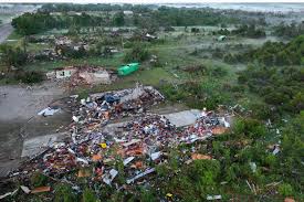
according to National Weather Service reports Storms on Sunday Were Confirmed to Have Tornadoes Near Crestwood, Midway, and O’Hare

Cook County As many as ten tornadoes were on the ground simultaneously from northern Cook to Kankakee during Monday night’s destructive storms that tore across Cook County, according to National Weather Service reports shared with Patch.
Earlier on Monday, winds associated with the system reached speeds of up to 80 mph west of Chicago. At 9:45 p.m., O’Hare International recorded a 75 mph wind gust. As a result, travelers took cover away from windows and the airport’s businesses closed.
The Chicago-Midway Airport weather observer noticed two tornadoes close to the South Side airport around 9:39 p.m. The two twisters occur one day after an EF-0 tornado that made landfall close to Midway on Sunday.
At 9:45 p.m., NWS radar indicated that a tornado had crossed I-294 into Crestwood.
“We won’t know the strength of the tornadoes until they go out and survey,” stated Danny Neal, an experienced storm chaser and Ford County deputy coordinator for emergency services. “There will be a ton of reports in the morning.”
When tornado sirens sounded over Oak Lawn, residents of the Airway Mobile Home Community ran, hiding in the Target parking garage. When the tornado warning for the area was canceled shortly after 10 p.m., a number of cars packed with neighbors and their dogs rode out the storm.
Two young girls who were seeking refuge with their family expressed a desire to shop at Target.
Their father retorted, “No, I want you here with me.”
A tornado warning that had been in effect for the entirety of Cook County until 10 p.m. was cleared as of 10:03 p.m., according to the National Weather Service.
Cook County is now Tornado Warning free as the circulations have moved over the lake. The potential for damaging winds will continue for the next 10 minutes! The line of storms with multiple tornadic circulations continues across NW Indiana and east central Illinois!”
The National Weather Service had posted on Twitter at 9:45 p.m.: “Dozens of circulations continue along this line of destructive thunderstorms moving across Cook County (including Chicago), the southern Suburbs south into Kankakee County. These will soon move into NW Indiana. Seek shelter until these storms move through!”

Be the first to comment