Ernesto’s Potentially predicted path is uncertain, although it is expected to reach Canadian waters by Monday.
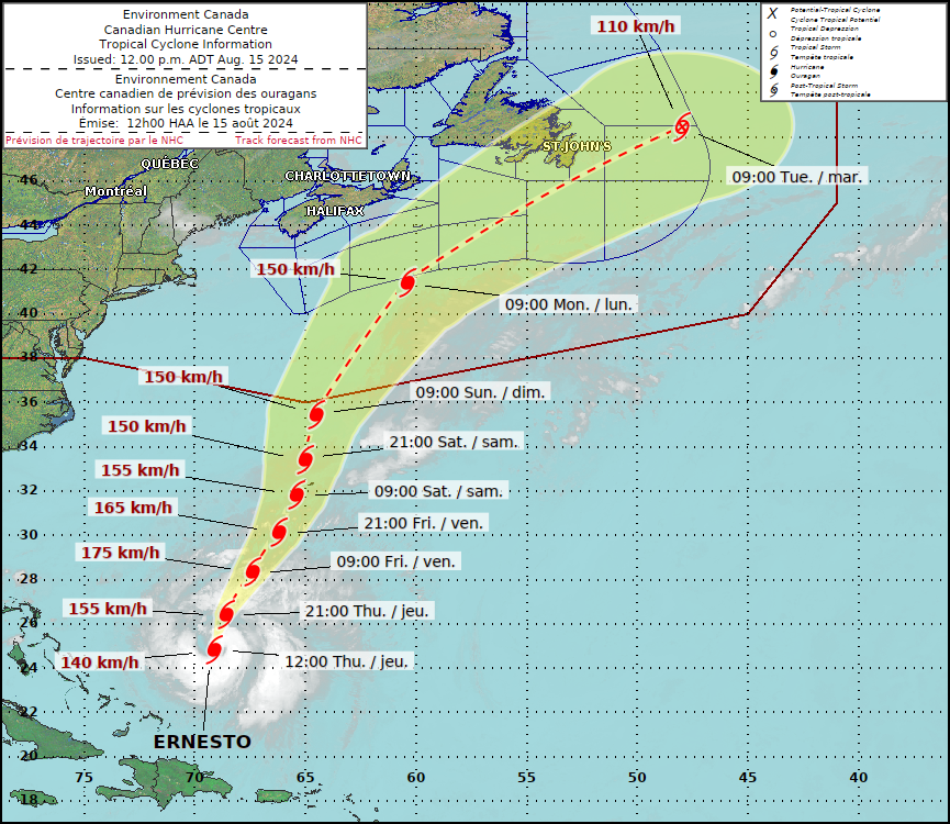
HALIFAX – Hurricane Ernesto is expected to move southeast of Nova Scotia by Monday, according to the long-term projection, but the Canadian Hurricane Centre says it’s still unknown how the storm will affect the Atlantic region.
The hurricane, which is predicted to impact Bermuda on Saturday as a Category 3 hurricane and cause strong winds and significant ocean swell, was predicted by the Halifax-based service on Thursday morning. According to the federal organization, such high seas will start to move into the Atlantic coast on Saturday and continue to build throughout the weekend.
Four and a half days remain until the storm makes landfall in Canadian waters, according to center meteorologist Chris Fogarty, who stated in an interview that “there is rather large uncertainty still.”
He did, however, caution that it’s too early to tell if the province will be affected by strong gusts and rain from the storm’s outer edge. Ernesto’s center is expected to be south of Nova Scotia as it moves northeast.
Ernesto is expected to have a “slightly greater possibility” of influencing weather over southeast Newfoundland, according to the forecast, and the agency is advising offshore oil facilities to “certainly pay attention to this storm.”
According to Fogarty, at this point, it seems likely that the jet stream will “steer the storm in an offshore direction.”
“The path taken by these storms is determined by the jet stream. It is more likely that the storm would remain offshore rather than approach land.”
Jet streams are “relatively narrow bands of strong wind in the upper levels of the atmosphere, typically occurring around 9,100 meters in elevation,” according to the National Oceanic and Atmospheric Administration of the United States. Although the winds inside jet streams flow from west to east, the band frequently moves north and south as it follows the boundaries between hot and cold air.
The storm close to Bermuda is getting stronger, according to the Canadian Hurricane Centre, partly because of the warm ocean temperatures.
Fogarty noted that the North Atlantic is less affected by this, though, because this year’s ocean temperatures close to the Nova Scotian shore are lower than normal.

Be the first to comment