Good morning, everyone! This is your First Alert Weather team, bringing you the latest updates as we head into the week. While we’ve seen some dry days recently, it looks like wet weather is making a return. If you have outdoor plans or need to be on the road this Friday, you’ll want to stay prepared for the rain and possible storms that will be moving in.
As we look ahead to the end of the week, a cold front is expected to push through the region, bringing with it widespread rain starting Friday morning. This system is part of a larger weather pattern that’s been developing over the past few days, and it looks like we’re in for a significant amount of rain. So, if you’re planning to spend time outside or need to travel on Friday, be sure to take the necessary precautions.
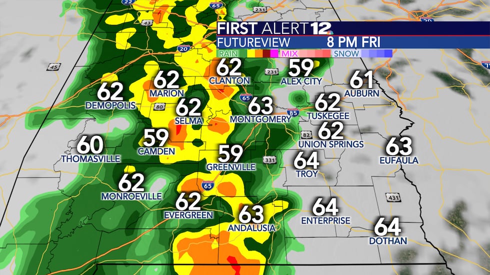
Rain will likely start as early as Friday morning, with heavier showers expected to move through by midday. We’re also tracking the possibility of thunderstorms, which could bring gusty winds and occasional lightning. These storms are expected to last through the afternoon and into the evening, so be sure to keep an eye on the sky as conditions can change quickly.
The wet weather will not be short-lived. While the rain may taper off somewhat late Friday night, the effects will linger into Saturday morning. The ground will likely be saturated by then, meaning localized flooding could become a concern, especially in areas with poor drainage or near bodies of water. If you live in a flood-prone area, it’s especially important to stay informed and take action if flood warnings are issued.
In terms of temperatures, Friday will be a bit cooler than usual, with highs likely staying in the mid-50s to low 60s. The overcast skies and rain will keep things on the chillier side, so be sure to layer up if you plan to be out and about. The rain will also make roads slick, so if you’re driving, take extra caution, particularly in areas where the visibility is reduced due to heavy rain or fog. Drivers should allow for extra time to reach their destinations and be aware of potential flooding on roadways.
By Saturday, the rain will gradually taper off, and we could see a brief respite from the wet weather, but don’t expect a completely dry weekend. Showers may still pop up throughout Saturday, especially in the afternoon and evening, as the weather system continues to move through. Sunday should bring a bit more sunshine, though there’s still a slight chance of rain in some areas.
Looking further ahead, we’re keeping an eye on additional systems that could bring more rain into the region next week. However, we’ll continue to track the situation and bring you the latest updates as we get closer to those days.
We understand how disruptive rainy weather can be, so we encourage you to stay connected with us for the latest updates on rain totals, flood watches, and any changes to the forecast. As always, be sure to have your First Alert Weather app handy, and we’ll keep you informed throughout the day.
That’s it for now! Stay safe, stay dry, and make sure to prepare for the wet weather on Friday. We’ll be back with more updates as the forecast develops.

Be the first to comment