We are witnessing yet another significant weather event unfold over the North Atlantic, with a powerful bomb cyclone developing near the United Kingdom. This storm, which has rapidly intensified over the past 24 hours, has drawn widespread attention due to its strength, speed, and potential impacts on the surrounding regions. The system is undergoing the classic “bombing” process, a term used in meteorology to describe a rapid drop in atmospheric pressure by at least 24 millibars within 24 hours. This intensification has made the storm one of the most formidable systems to affect the North Atlantic this winter season.
**What is a Bomb Cyclone?**
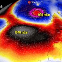
A bomb cyclone, also known as explosive cyclogenesis, occurs when a storm rapidly deepens, leading to significant shifts in the weather patterns surrounding it. In the case of the current system near the UK, the pressure has dropped drastically, leading to a rapid intensification of the storm. These cyclones are often associated with extreme weather conditions, including heavy precipitation, strong winds, and severe coastal flooding. The term “bomb” refers to the explosive nature of the pressure drop, which fuels the cyclone’s growth and can create hazardous conditions across vast areas.
As the storm continues to develop, the pressure drop is likely to continue, making this bomb cyclone a serious concern for both the UK and other areas along the North Atlantic coast. Meteorologists are closely monitoring the storm’s behavior, as such systems can lead to significant disruptions in transportation, energy, and coastal infrastructure.
**Impacts on the United Kingdom**
The UK is already experiencing the early effects of the bomb cyclone, with high winds and heavy rain impacting parts of Scotland, Northern Ireland, and northern England. Wind gusts are expected to reach up to 80-100 mph in some areas, making travel hazardous and posing a risk to both marine and land-based structures. Coastal regions are especially vulnerable, as the combination of high winds and a rising tide could lead to coastal flooding, exacerbating the impact of the storm.
In addition to the wind and flooding, the cyclone’s heavy rainfall is expected to lead to river and surface water flooding, particularly in areas that have already been saturated by previous storms this winter. Local authorities have issued warnings for vulnerable regions, urging residents to take precautions and remain alert to changing conditions. Flooding could cause road closures, power outages, and disruptions to public services, particularly in areas already struggling from recent storms.
**Wider North Atlantic Effects**
While the UK is experiencing the most immediate effects, this bomb cyclone is also expected to impact surrounding areas of Europe, including Ireland, the Netherlands, France, and parts of Scandinavia. As the storm moves eastward, strong winds and rough seas will affect shipping and maritime activities, and large swells could pose significant risks to coastal communities. The North Sea could experience extremely dangerous conditions, with waves reaching up to 40 feet in some places.
In addition to the storm’s direct impacts, the rapid intensification of the cyclone is likely to disrupt the broader weather patterns in the North Atlantic. Such powerful storms often influence atmospheric circulation, leading to changes in the jet stream and weather conditions further afield, even across parts of North America.
**The Role of Climate Change in Bomb Cyclones**
This bomb cyclone serves as a reminder of the growing intensity of storms in the North Atlantic, which may be linked to the broader impacts of climate change. Warmer ocean temperatures provide additional energy to these systems, which can lead to more extreme weather events. While bomb cyclones are not new phenomena, their frequency and severity seem to be increasing, raising concerns about the resilience of coastal infrastructure and communities in the face of stronger storms.
In the coming days, it will be crucial for residents and authorities to remain vigilant and prepared for further developments as this bomb cyclone continues to strengthen. Weather advisories and warnings are expected to update frequently, and local governments are advising caution when traveling in affected regions.
Stay safe, stay informed, and let’s continue monitoring this situation as it unfolds.

Be the first to comment