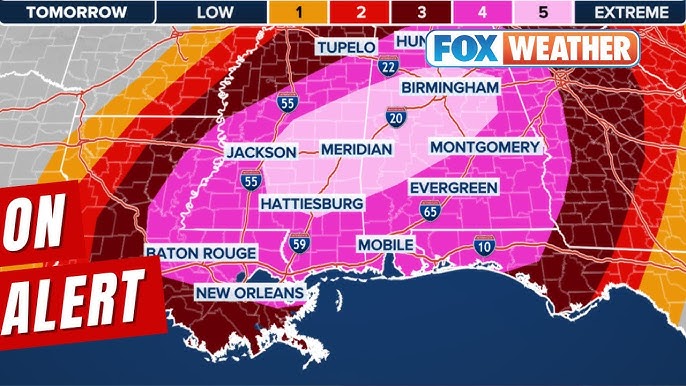
Millions of Americans are preparing for what could be a dangerous and widespread tornado outbreak this Saturday, as meteorologists have issued the highest level of severe weather risk. The National Weather Service (NWS) has classified the threat as “High Risk,” the most severe level, signaling the potential for widespread and significant severe weather across parts of the Midwest and Southern United States.
The severe weather outbreak is expected to begin Saturday afternoon and last into the evening, with conditions ripe for the development of violent thunderstorms, large hail, damaging winds, and potentially multiple tornadoes. The risk area stretches from the Great Plains to parts of the Midwest and Southeast, with areas such as Oklahoma, Texas, Arkansas, Louisiana, and Missouri among the most vulnerable to severe storms.
This severe weather event is being driven by an unusually powerful low-pressure system that will interact with warm, moist air surging from the Gulf of Mexico. These conditions are primed to produce the ideal environment for tornadoes. The primary concern is that some of these tornadoes could be strong, with winds in excess of 100 mph, causing widespread destruction. Forecasters are particularly concerned about the possibility of long-track tornadoes, which can travel significant distances and cause substantial damage over large areas.
The timing of the storms is also a major concern, as they are expected to unfold during the afternoon and evening hours when many people are at home, making it crucial for everyone to be alert to changing conditions. While tornadoes can strike at any time, the risk is particularly high in the late afternoon and early evening, when conditions are most conducive to severe weather.
In addition to tornadoes, destructive winds and large hail are expected, which could cause damage to roofs, windows, and vehicles. The storms could also bring heavy rainfall, leading to flash flooding in some areas. Flash flood watches have already been issued for regions expected to receive heavy downpours, with some locations at risk for 2 to 4 inches of rain or more.
Emergency preparedness is crucial as the storm approaches. Local authorities are advising residents in affected areas to finalize their plans for shelter, especially if a tornado warning is issued. Those in mobile homes or temporary structures are particularly vulnerable and are encouraged to seek shelter in a more secure building if the weather worsens. It is also recommended that families stock up on essential supplies, such as bottled water, non-perishable food, flashlights, batteries, and first-aid kits.
Additionally, people should make sure their phones are charged and download weather apps that provide real-time alerts. It is important to stay tuned to weather updates throughout the day on Saturday, as the situation is expected to evolve rapidly. The NWS will issue watches and warnings as the storm develops, and these should be taken seriously.
For those living in high-risk areas, the upcoming weekend may be a time to take extra precautions. While the storm’s exact path remains uncertain, the sheer scale of the potential outbreak makes it vital to be prepared for any eventuality. The severity of this weekend’s weather serves as a reminder of the importance of paying attention to weather warnings and having a plan in place to protect yourself and your family.
As Saturday approaches, authorities and meteorologists will continue to monitor conditions closely. They are expected to provide further updates on the scope and timing of the storm, but residents in high-risk areas should act now to ensure their safety before the severe weather strikes.


Be the first to comment