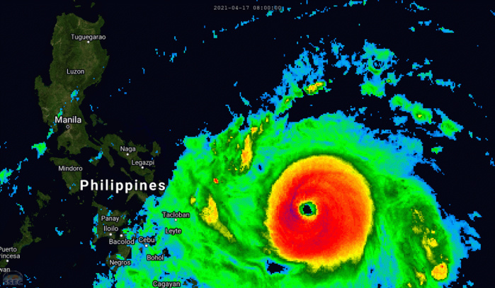
Super Typhoon 02W, also known as Surigae, made a profound mark in meteorological history as one of the strongest storms to form in the western North Pacific. As it intensified and moved northwestward toward the Philippine Sea, Surigae’s power and unpredictability earned it a reputation as a formidable force of nature. This super typhoon’s journey, reaching its peak intensity in mid-April, was one of rapid intensification, illustrating the sheer power of nature and the immense challenge of forecasting such intense systems.
Surigae’s rapid strengthening began on April 16, when it started to undergo a period of intense intensification, ultimately reaching its peak intensity on April 17, 2021. At 1800 UTC on that date, Surigae was packing maximum sustained winds of 165 knots (about 190 mph). This intensity marked it as a Category 5-equivalent storm, putting it in the highest tier of tropical cyclones. Surigae’s intense winds and its incredibly low central pressure made it one of the most powerful systems of the season, and certainly one of the strongest storms in recent memory.
The Japan Meteorological Agency (JMA) estimated Surigae’s minimum central pressure at 985 millibars, while the Joint Typhoon Warning Center (JTWC) recorded it slightly higher at 988 millibars. Both of these pressure readings reflect the storm’s intensity, with the lower the pressure, the more intense the system. This discrepancy in readings highlights the challenges meteorologists face when analyzing such a dynamic storm, but the general consensus was clear: Surigae was an extraordinarily strong typhoon.
The storm’s rapid intensification was particularly significant. Typically, typhoons can take several days to reach their peak strength, but Surigae was able to quickly harness favorable atmospheric and oceanic conditions. The warm waters of the Philippine Sea, along with low vertical wind shear and a conducive environment, allowed Surigae to grow into a powerhouse within a relatively short timeframe. These conditions made it a subject of intense observation as meteorologists tried to predict its next move, especially as it approached the Philippines.
The potential for damage was clear. Surigae’s winds, reaching speeds that could cause catastrophic damage, coupled with the threat of intense rainfall and storm surges, made it a serious threat to coastal communities in its path. With the storm’s rapid intensification, there were concerns about the limited time available for preparation and evacuation in vulnerable areas.
Despite Surigae’s immense strength, its behavior wasn’t entirely predictable. While it peaked at Category 5 strength, the future trajectory and strength of the typhoon would depend on numerous factors, including interactions with land, changes in sea surface temperatures, and the atmospheric environment. These variables make predicting the final impact of such storms difficult, and meteorologists worked around the clock to adjust forecasts and issue warnings to ensure the safety of affected populations.
Surigae’s power and unpredictability serve as a reminder of the immense force of nature that tropical cyclones can be. They can intensify rapidly and without warning, posing a significant challenge to those in their path. The need for accurate forecasting, timely warnings, and efficient emergency response systems is vital in minimizing the devastation caused by such powerful storms.
As we reflect on the strength and ferocity of Super Typhoon 02W (Surigae), it serves as both a testament to the incredible power of nature and a reminder of the resilience needed in the face of such overwhelming forces. May we continue to improve our ability to predict and respond to such natural disasters, ensuring that communities can be better prepared for the next super typhoon that may come their way.

Be the first to comment